


![]()
1 Like
There shouldn’t be any reason why you can’t run a typical base and Rover setup. Looks like you are in an awesome situation with an area to setup your own network of control that shouldn’t be too tough, but would be very impressive. If you could get to a central point of your typical survey area and set a base for 1 hour then you will collect a very accurate coordinate to start your network. From there use your Rover to spiderweb out and set additional base stations. You can always check your points from secondary to secondary point or 3rd generation to 3rd generation point. If you know someone that can run a level loop even better
1 Like
Yeah, i don`t see why this should be hard area to work in.
High density of refrence station and lots of hula hula all year long.
Just hit the invisible/famous GNSS wall. Once one get over this it’s all awesome
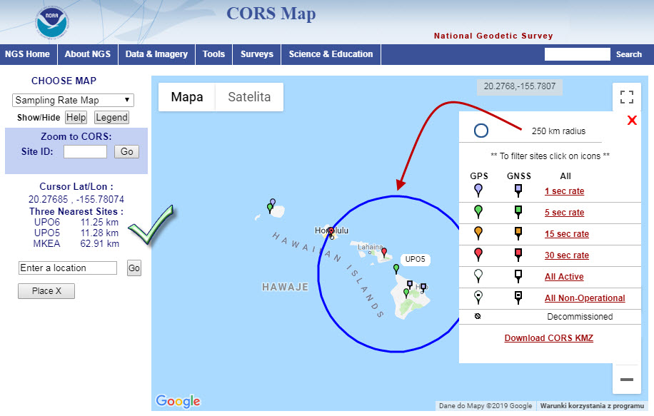
You don’t need NTRIP for GCPs. You don’t even need the other Reach RS+ as base so don’t have to worry about RTK. To keep most simple grab your rover and start surveying project in Reachview. Yes, all your solutions will be single during survey but just occupy each GCP for a minimum of two minutes (more or less depending on where placed - but just be smart where you place them). Then PPK your raw rover log (plenty of resources here to get started) to one of the many CORS sites in Hawaii. Your survey is now absolute and tied to a known point.
I just did a survey like this because a big rig blew my rover tripod over and obliterated my LoRa. No base connection but I just continued to survey as normal cognitive to the fact I was going to PPK my solutions.
Or if you want to RTK run base and rover in field then PPK back in office first your base position then your rover from that now known base position.
A big what?

I kinda agree on GCPs, but it depends on what your end goal is. If you want 10cm in your control network you are not going to get it with just a rover. In addition to that if you are trying to relate it to any local datum you need to be within at least 5cm on your GCPs to be confident in you end product. Otherwise you might as well use the coordinate and geoid conversion plug-ins for Google Earth for your control. I can consistently tie-in within 20cm of geoid grade without survey-grade control.
That is what I do when I’m to far from cors stations or cant access the nearest one. Not sure now it works in the US but the state body should publish data of all permanent survey marks. In Australia this is normally via a web portal which will let you clip and ship a csv log. This can then be converted format (if required) and loaded so you can even stake out your known points to help you with finding the marks.
Processes if normally then to place Base on known point set as base and then use loRA for rtk corrections. If this fails you can always post process just make sure you have a base running for the whole survey period.
1 Like
This topic was automatically closed 100 days after the last reply. New replies are no longer allowed.