yesterday and today I took the RS2 to a benchmark that is 2km from the CORS station (ZME1). My PPK Elip height was off by .550 meters. Does anyone have any ideas on what the problem might be?
Link to Benchmark data https://www.ngs.noaa.gov/cgi-bin/ds_mark.prl?PidBox=AJ2643
Also check what your CORS station is using. It might not be WGS84 either. So you might have to do a couple of coordinate transformations to get a result that compares well.
Tim, I am positive it is not 2.37m. I did make one error in that I forgot to change my Disto to read from the front end instead of the back end (I measured from the top of the tripod down to benchmark and then added .377 meters (measurement of tribrach and extension pole) to that reading. I realized last night that I had forgot to change the disto to read from the front instead of the rear as I would just always take a reading from the bottom of the Reach RS in the past.
This is not an issue with the CORS station as I have had zero issues in the past processing my previous Reach RS units with very good accuracy using this CORS.
This is the first time I used this particular benchmark but I went to it since it was very close to the CORS station (2km). Today I hope to have time to run back and redo the this particular benchmark and also survey the two benchmarks within 500’ of the CORS station.
I have to map a crash scene on Saturday and I was just double checking the accuracy of my new RS2 units.
Are the corrections from the base station not independent of the reported base station CRS? I always thought the raw base station corrections were always WGS84 since this is what all GNSS measure naturally and that one only needed to adjust the rover positions in post to match the CRS of the reference point??
The PPK software is simply reading the position data in the rinex file and applying that data to various datums. For right now, I have had to enter a -0.429m offset for my post processing. When I use that value my PPK numbers are within 1cm or less of the Benchmark data (x,y,z). I have not had time to figure out why but as long as it is accurate, I am good. I did multiple test with different benchmarks and both RS2 units and using the -0.429m offset provides very precise results. Unfortunately I had already sold and shipped both Reach RS units to be able to mount them on the same stand and do back to back test. But for now my results are spot on and it is back to work.
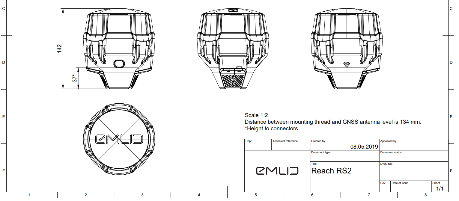
Just some math but I see you added .377 meters. I dont have RS2 but see that distance between mounting thread and antenna is 134 mm or .134 meters. So 0.377 + 0.134 puts you at about 0.511 meters. You were off by 0.550 meters so thats only 4cm difference which may be explained by movement in the plate vertically. I’m in California and things like to move
For the sake of precision in testing I did the following:
Setup tripod base over benchmark. attached tribrach with laser plumb. leveled and centered.
Removed tribrach and laser measured from top of tripod to center point of BM.
Reattached tribrach, and then attached mount, extension pole and RS2. The distance from the bottom of the tribrach to the bottom of the Reach RS2 is .377 meters.
I added laser measure + 0.377 and that is my antenna height. Reach View already adds the 0.134 value to the pole measurement in the CSV file.
Now when I post process, I had to make a -0.429 adjustment and my end results are spot on. I had to uninstall and reinstall EZsurv because I ran into problems but after reinstall it is running fine. Still no idea why the offset is needed and maybe next week sometime I can find out more. I processed test from today as already described and that is what I used to compare.
I will say that I have 99% confidence that this error is on my end. There is no way that I have the only 2 units that are offset by almost a 1/2 meter :0 This was not an issue with the Reach RS units so no idea what it could be. I will certainly get to to the bottom of it. Tonight I will process on a different computer to compare results. Luv the RS2 units. they are very nice! For now an offset number will work