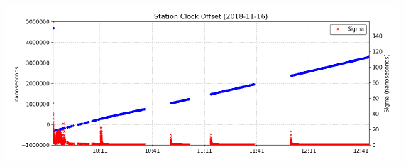
Thank you so much guys for trying to post process my point, I really appreciate that. Last week I was trying to PP my data and I used camo reference station as well, but unfortunately, I got the same output that I sent it to you earlier. I still struggling in post processing my data.
Hi Andrew,
I have both receivers (rover and base), I should measure around 21 points in Penryn (this is my pilot experiment), so I was thinking to establish known point first (I did that by using rover Not base receiver, and as illustrated in Emlid Docs: I used ReachView, create job; start measuring points; and after 2h and 45 min I stopped the measurements).
However, this point has Not been processed by me yet. I still do not know how to do it correctly (this is my first time using EmlidReach). Please if you have any suggestion/ if you noticed that I did something wrong based on what I wrote here, please correct me. I can repeat the measurements, once I know/ understand how to avoid the mistake/s that I did in the first time.
Thanks a lot 
Your surveying is very poor quality. My advice is to check the quality of the survey before starting any post-processing.
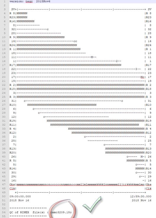
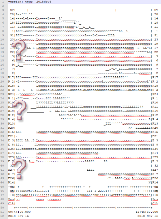
You can do it in several ways. One of them is the use of teqc.exe.
Another, much simpler is the use of the Canadian CSRS-PPP. Not for the result, just to check if your measurements are good.
In your example, there was no need to measure at the interval of 0.2 seconds only at most 1 second, or even 10 seconds, because the reference station is with an interval of 30 seconds. Hourly RINEX files have to be combined into one for RTKPOST (very simple by teqc).
camo320xxx.pdf (1.1 MB)
ik2813200.pdf (1001.4 KB)
camo320xxx.obs (531.0 KB)
At the end of something optimistic. Despite this, there is no need to repeat the observation. Just postprocessing through the VRS. ![]()
They dont, they Can just be wildcarded instead.
Many thanks Ryszard Pażus, I will try using one of them, hopefully at the end I can post process my data.
Yes Andrew, I have two Reach RS+ devises, I named one of them rover, and the second one is the base.
I was curious about the teqc.exe tool so I downloaded the Windows 64bit zip file. I unzipped it but the teqc.exe file did not work. It flashed a box up on the screen for 1/2 second and then disappeared. Just passing on in case someone else has the same issue. I even tried the 32bit with same results.
Yes, it’s a DOS program and can be with a Command prompt (Click start then type CMD to get a command prompt with Windows 7)
Dave.
I think it’s a command line tool, so you need to run it through a command prompt, or, if it’s smart, drag multiple files on top of it, and release.
Edit: @myozone was a few seconds faster 
Thank you both. Did not dawn on my it was CMD program.
Hi @ik281,
So, if you’ve base and rover, I think that the best workflow will be the following:
- Install device above the future known point
- Turn it on
- Stay on the point for around 30-40min
- Turn off device
- At home download RINEX file of your nearest local station for the same survey period
- Process device log file relative to RINEX station
- Now you have absolute coordinates of your known point
- Use it next time you’ll survey, manually filling the base position on Reach base.
I’d recommend you to read these articles about placing the base and post-processing.
Also, you’ll find a lot more info about similar workflows by looking through our community forum and using the search tool.
Thanks Andrew,
I just have a few questions, and I would be very grateful if you would answer them clearly:
-
which device, the rover?
-
After I turn it on, I should create a new point, name and setting the point,and then, start measurements?, or only Enable logging of raw data and record log for a few hours?
-
30-40 min is too short, I think it is better to leave the point at least 2 hours to get higher quality?
-
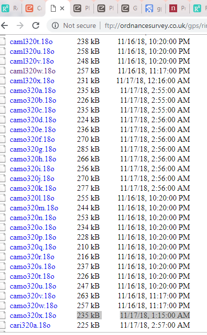
So, because I am in Penryn, Camo station would be the nearest one: I’ve selected the most updated station that is measured in 17th Nov, is that fine? (highlighted it here):
-
This is my main issue: data processing, I still do not know how to get the corrected coordinates from RTKLIB,
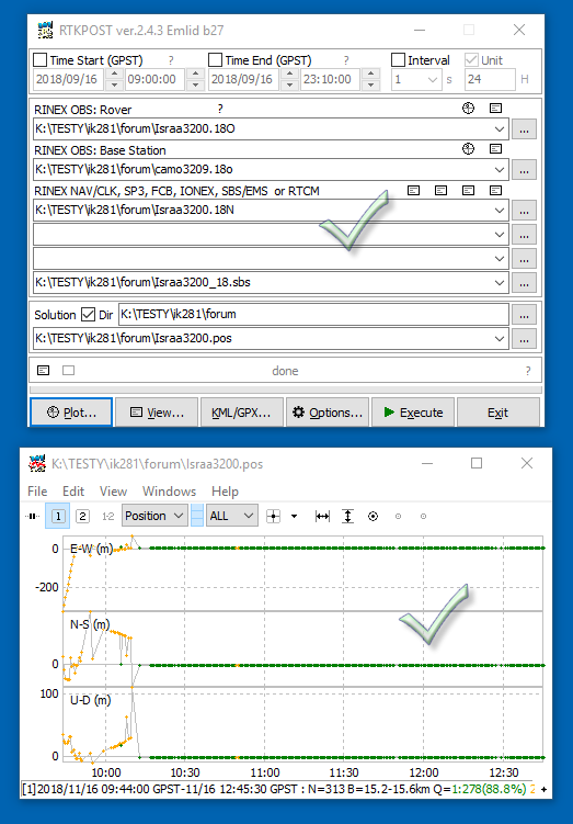
@myozone has processed the data by RTKLIB, as shows below,
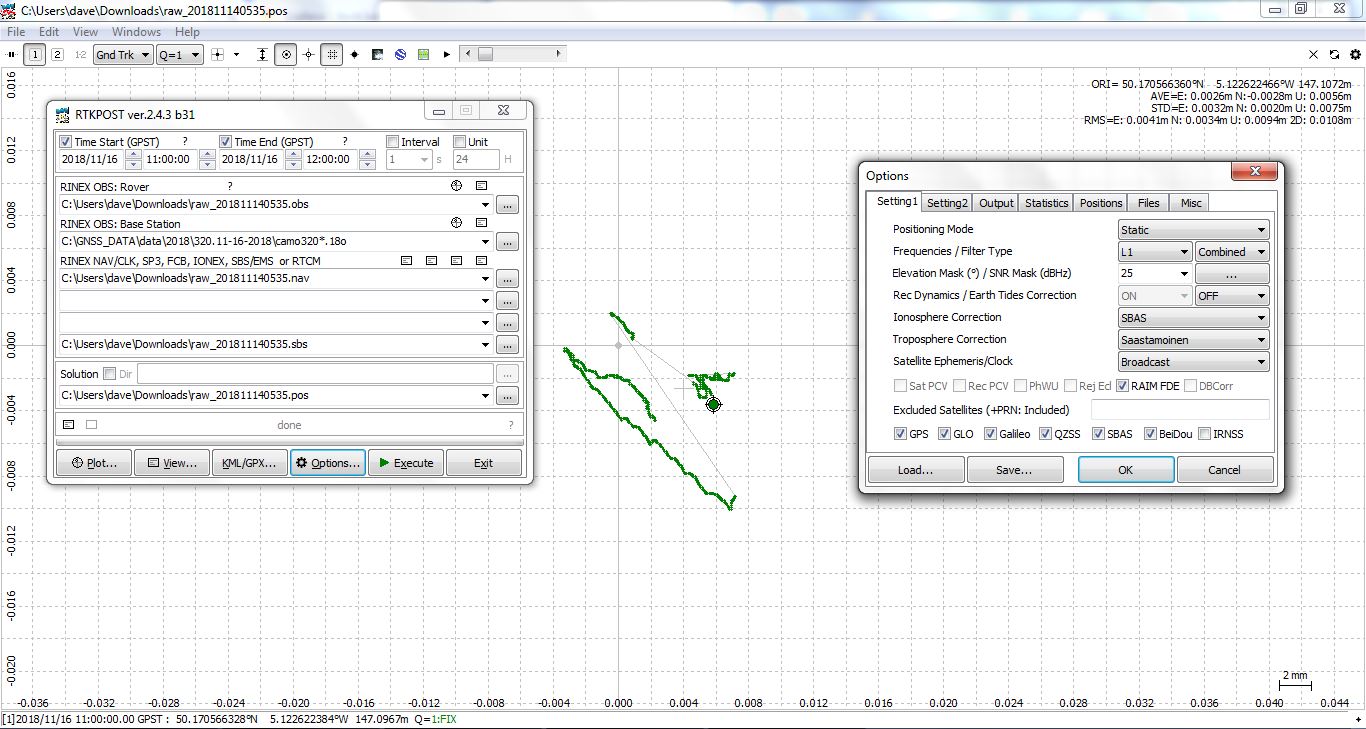
would you please tell me what the output file (the last line ends with pos: I do not have this one)? did you change files format, so you can read the output? (it appears empty files to me) if yes, how you change them?
Thanks so much,
Hi Israa,
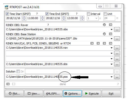
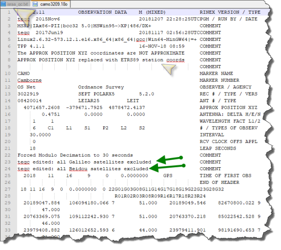
I can answer one part of your question. The files that you get from the Ordnancesurvey are supplied in 1 hour chunks for each day starting at 00:00-00:59 being labelled ‘a’ 01:00-01:59 ‘b’ and so on to 23:00-23:59 being ‘x’. Therefore, it best download the entire day a-x. This is done with a ‘wildcard’ * character in RTKpost - if you look carefully in my example the base is camo320*.18o being the entire days data that is used for corrections and of course only the corresponding obs file time range is used being 11:00-12:00 in my example. As to the rest of your question I’m not sure, because I don’t have any Emlid equipment.
Dave.
Thanks Dave, I downloaded each one separably (from a-x) and put them together in one folder.
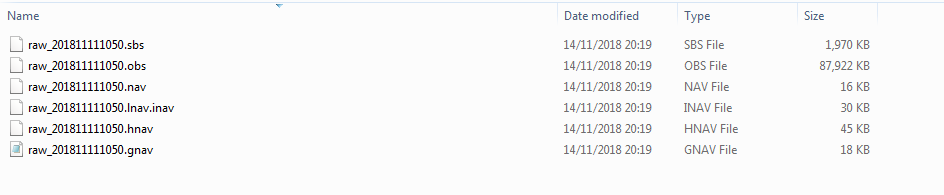
I am just wondering, I only sent you UBX file, but you could process my data successfully. Could you please tell me how you get obs, nav, and sbs files.
In my side, I downloaded RINEX folder (they are in RINEX folder) 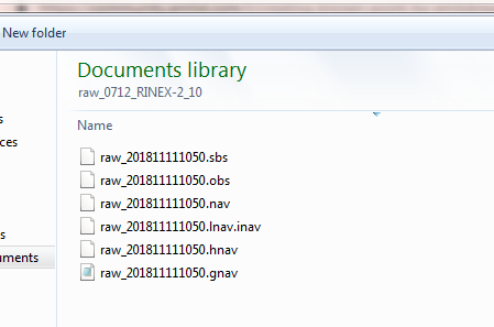
Also, I noticed that you have pos file, I do Not have this one. Would you pleasee tell me how you got them? I might know after that how to process the data successfully ‘hopfully’
Thanks,
My tips are as follows:
- do not start computation without analysis, i.e. pre-processing,
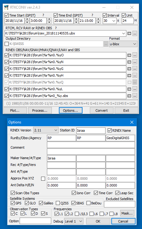
- do not make such measurements with an interval of 0.2 seconds, if you have done preprocessed by RTKCONV for 30 seconds,
- you need to combine your base reference hour sessions into one RINEX file (teqc.exe)
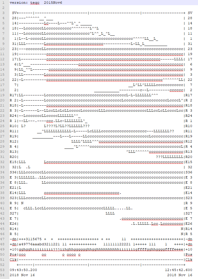
The following graphics explain everything. You have the rest in the attached files.
ik281.zip (517.5 KB)
Hi Israa, I don’t want to confuse you nor override what Ryszard is saying but here goes.
The nav, obs and sbs files are contained within the UBX file and RTKconv extracts those for you, and the base obs file(s) comes from either your own base or another source - Cambourne in this case as you already know.
If you use RTKpost with the same settings as my example you should get the same results and the pos file you need. These maybe slightly different from what Ryszard saying but it does work.
Dave.
If you are to return to this point over an over again, I would stay on the point for ~24h to average things out. I will also recommend that you reprocess it when Precise clocks and orbits are available to you (1-3 weeks after, depending on the source)
Not sure what you mean here? Do you mean conversion of the .ubx file?
Nop, you don’t need to, it’s easier to just combine the files in rtkpost using a wildcard.
Thank you so much @r.pazus for the explanation and thanks a lot Dave @myozone
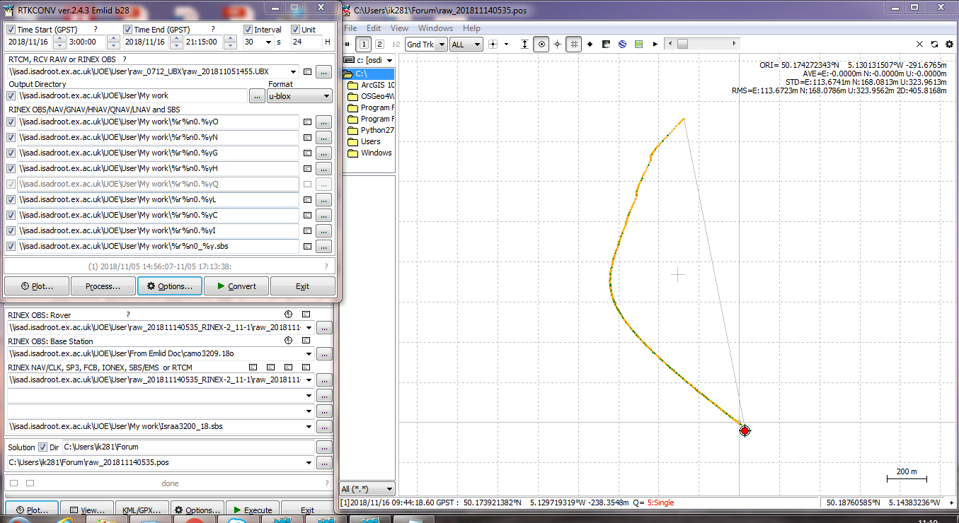
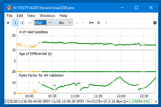
I’ve tried to follow the steps that written above since last Thursday, but it was not working. Toady, I tried again and the corrected data with std and RMS, both RMS and Std are too high, as shown below (it is supposed to be same results (RMS= 4 mm horizontally and 9 mm vertically) to what Dave’s sent earlier). Any thoughts to obtain data correctly pleaase?