If you’re based in the UK and have experience with setting-up and using Reach RS, please get in touch.
I need some mentoring/ guidance as I can’t get the base and rover to work together.
My devices are only a few meters apart, yet the baseline is showing as 5km.
There are so many settings and I’m struggling to find the right combination for best use in the UK.
I want to capture the co-ordinates (long and lat, not elevation at this stage) with the rover, and correct using the base in real-time if possible or post-process if I have to.
The Emlid docs assume that the user has experience with this technology, for example:
“Now you should repeat the same with base log. Don’t forget to change format. After that you’ll see something similar in your output folder.”
I didn’t understand/ couldn’t follow the setup for the rover, never mind the base;
Change format from what to what?;
What output folder?
I used the ReachView app on my Android phone, downloaded the raw files from both the base and rover, then emailed these to myself so that I could bring them over to my laptop.
I then extracted the files, opened the post-processing app then opened these files in the RTKCONV app, followed the instructions as best as I could, but just got frustrated with it.
I must be missing something fundamental here - please help if you can.
The docs state setting-up the base then obtaining an averaged co-ordinate over a period - is that 10 min, an hour, a day? I was hoping to mount the base on a vehicle, then carry out a quick survey, then drive to the next site and repeat several times a day. This would be to survey public
roads.
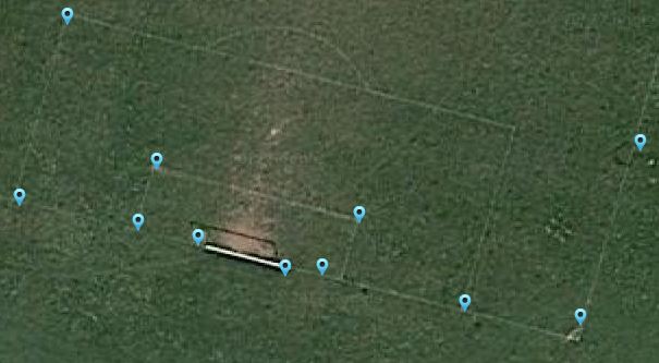
I decided to survey a local football field, as you’ll see attached, where the co-ordinates were captured with the rover only then plotted into Google maps via GeoJSON format.
The line widths are approx 150mm and I place the roverd directly in the center of either the straight lines or at the intersecting corners (as best as possible, mud and all) .
The results are pretty good.
We’ve written our code for offsetting the blue markers to correct the captured co-ordinates, then to measure the area between these corrected markers.
This saves the need for post-processing or using the base for RTK corrections.
Obviously, RTK corrections with the base would enhance the accuracy.
I couldn’t get the base to connect, so will try again shortly.
How are you getting on with the Reach RS.
I’m interested in using a base and rover set up for surveying applications and just wanted to get a UK based opinion on the system.
I’m being guided by someone here (Peter Jones) to set up an RTK solution via NTRIP to stream base corrections over the internet to my rover.
I’m new to this tech, and have only been using Reach RS for a few weeks now.
we are based in Devon and are fairly new to it too we have been using total stations for years but we are getting asked for GPS coordinate more and more.
As our phone signal is poor at best in most places we were thinking of a base station for the corrections.
is there a subscription charge with the NTRIP?
Using the rover on it’s own to collect co-ordinates is straightforward - you can download the GeoJSON file then import into Google maps to show them as plotted, like on the football field above.
It depends on the accuracy you need.
I need ±10mm, hence trying to correct using the base.