Does anyone know the receiver radio sensitivity on the reach rs+ units? Haven’t found those sort of specs in the docs. I.e. -80dB or something?
Another thought I just had, what is stopping me from raising the Reach (provided it is on a firm tripod on a roof etc) to shorten cable length? In my head, I’m remembering there is a height offset limit of about 6m, but does that apply if I’m gaining a base station position from another base? I.e from the CORS network in Aus? Or is the 6m elevation limit to do with the actual transmittable elevation over the LoRa via NMEA strings?
The receiving sensitivity of Reach RS+ LoRa module is -132dBm.
Regarding antenna height offset, it’s limited only when you manually place your base station. So in case you use averaging, it’s possible to raise the antenna higher.
With regard to the antenna offset, I guess the notion is about your base coordinate. If you use a mark on the ground, then you need to correct by applying antenna offset. However if your base coordinate IS your base antenna position, then there is no offset. And that doesn’t matter if it is on a tripod or on a tower or a pole.
You still might want to make a permanent mark on the ground so that you can check that a pole or tower-mounted base has not shifted over time (or from severe weather / earthquake, etc. - or possibly temperature if you get that picky!).
I’ve placed my base manually having a friend placing his rover on the pole and I received the coordinates which I manually typed in and it was not successful. it is because it is on 9m hight instead of 6? if I go auto I am getting the position. As we are using Stereo 70 coordinate system it is probably all messed-up .
in this case what options do I have?
-lower the Base
-extend the Lo-Ra with a cable to the 9m point
Is it any updates on using different coordinates systems with Reach RS+? our farm cadaster is all in Stereo 70 and it would be great to work directly in Stereo 70.
In that case I think your antenna height would be entered as zero because it is the same height as the coordinate that was captured by your friend’s rover.
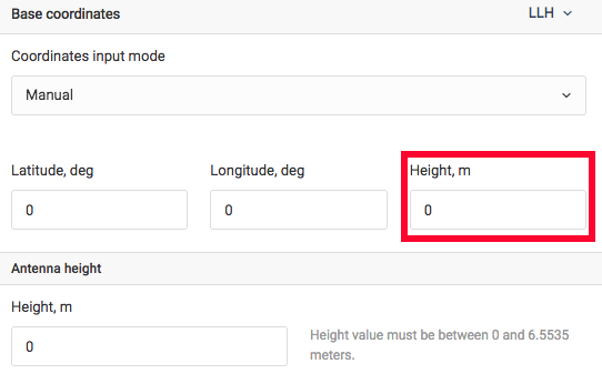
You can also take your antenna height into account when entering point’s height in “Base coordinates”. I’ve marked it by red in the attached screenshot.
Well, it is a bit confusing. The hight in the first line where Lon and Lat is, is the actual Base hight and the " Antenna hight" below is the extension coax ?
You have a survey marker on the ground with a specified LLH coordinate, and you put that exact LLH coordinate into your Latitude, Longitude, Height fields in ReachView
You have your GNSS receiver on a tripod perfectly centered above that survey marker, and you measure the height from the marker to the “antenna reference point” and enter that into your Antenna height field in ReachView.
Both of those figures add up to the actual elevation that is relative to the surface of the WGS84 ellipsoid.
By entering the two heights separately, you can easily compare and see that each one is correct. BUT if your antenna reference point is too high above the survey marker (>6.5535m), then you will have a problem with the limitation noted here:
So, what @tatiana.andreeva is saying is that you could take any excess antenna height and add it to your survey marker height. That way, you are not restricted by the antenna height limitation.
Example:
Survey marker height: 100m
Antenna height on tower: 20m
ReachView won’t allow 20m antenna height, so enter these values instead:
Base coordinate height: 120m
Antenna height: 0m
Easy!
All that matters in the end is the elevation of the antenna itself relative to the WGS84 ellipsoid. It doesn't matter about your coax length or tripod/tower height or distance from the ground.