This model would not be received well by many surveyors. Technology replacing years of study and membership in an exclusive club…heck no. If it were available to only them, then by all means. But to the masses, no way.
Disclosure; The above describes 7 out of 10 surveyors I have interacted with. The other 30% are generally very helpful and not condescending.
Surveyors would take this model just fine because it really wouldn’t change anything they do. If anything it gives them a new breath of life. Surveyors get bent out of shape because they are undervalued and threatened by technology because it gives the people a false sense that they can do what a surveyor does when in fact they have no clue what an RPLS is capable of. Surveyors work with elements of geometry, trigonometry, regression analysis, engineering, metrology, physics and law. surveying is a scientific, mathematical and legal profession. They are bound to doing things the right way every time. People should learn how to use a plumb-bob, run a level-loop, keep field notes, run a chain and hand calculate coordinates before they get too high and mighty. I backup real surveyors because if an EMP hits or something happens to the satellites most people will be left with piles of useless electronics. I find that only 3 out of 10 surveyors are bad.
The little I have learned, I have great respect for what someone goes through to become a licensed survey professional. The 7 out of 10 I mentioned, I would not call “bad”, although as in any profession there are probably good and bad at what they do. My comment is more about their attitude, not knowledge or skill.
To the subject of this thread, From my layman’s perspective, here is the problem with what is currently in use. We have various datum, geoid, and local models which have evolved over time in order to more accurately reference points on the earth. Everything is or needs to be referenced to one or the other and often needs converted to yet another.
As Michael pointed out, real work on the ground involving multiple participants involves a dance of reconciling all of these reference translations into something that can actually be used to dig holes in the right spot. In every step, there is the chance that an error will be introduced.
A single dynamic, constantly evolving datum/geoid should be achievable with today’s technology. But maybe that is naive on my part. It seems like as soon as a static model is (or was) established, it begins to degrade because the earth is not static. Thus, at some point a “new” more appropriate model is layered on the existing pile.
Since every point is “relative” rather than “absolute”, perhaps the most difficult step in the “nirvana datum” would be to decide on the Prime point from which everything else if referenced.
But in this day and age, instead of using a flat folded up map, we need this to be updated also. A dynamic realtime reference to all of this. I guess something 3D like GoogleEarth? Just requires a device rather than a map projection stretched out on a flat piece of paper.
Edit: but how do you produce a DYNAMIC deliverable? It wouldn’t be on paper the old school way, but digital. A file that would need to be loaded then print deliverables from there at the time that was needed. The problem with things that change over time and are not static.
I totally agree with you that a master datum is achievable and actually is already here - horizontally. There are allot of social and political divides that will not allow us to get there. The inability of the US Congress to mandate the use of the metric system is laughable and I think making anyone do math with fractions is criminal. At least surveyors use decimal feet.
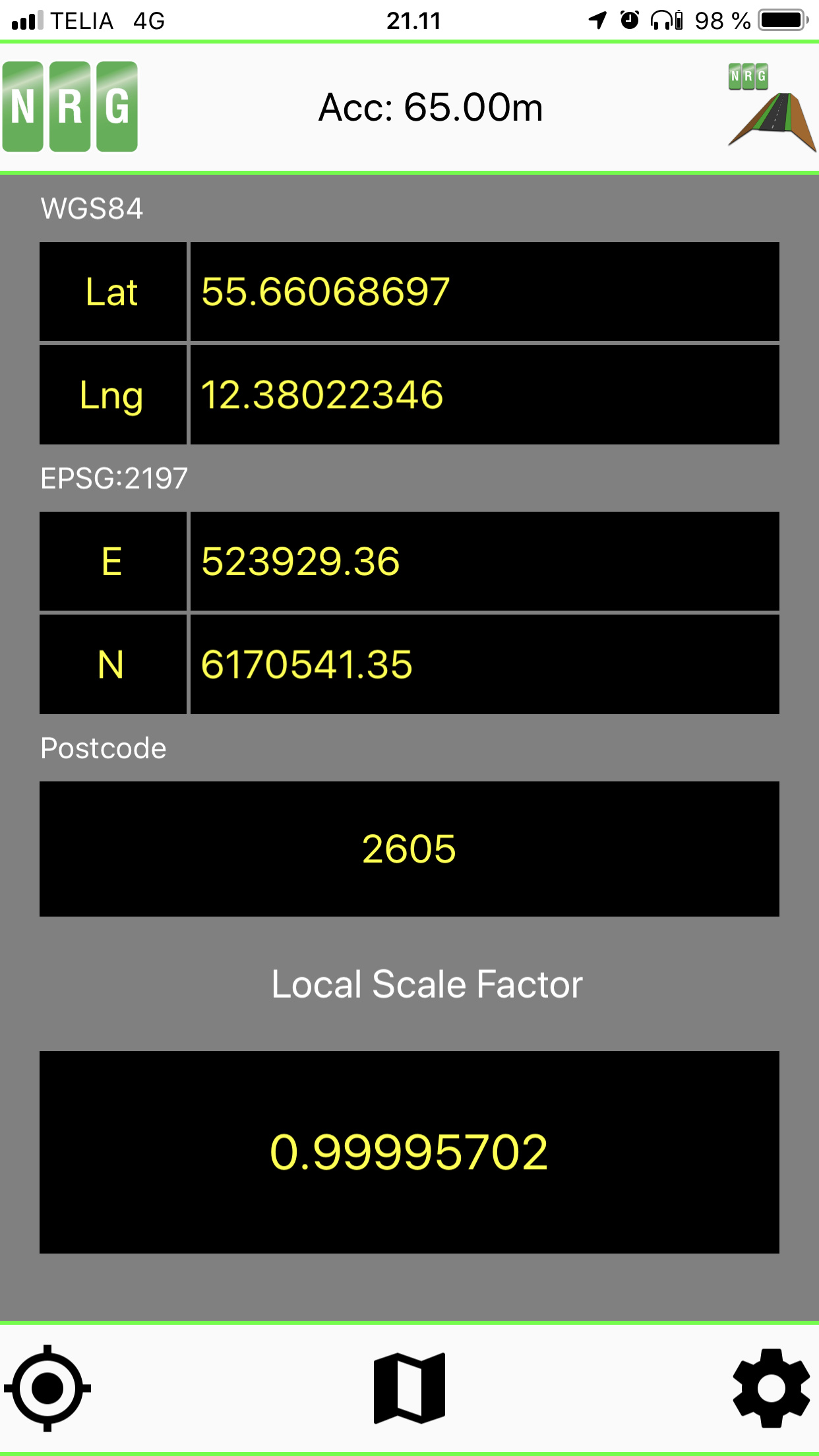
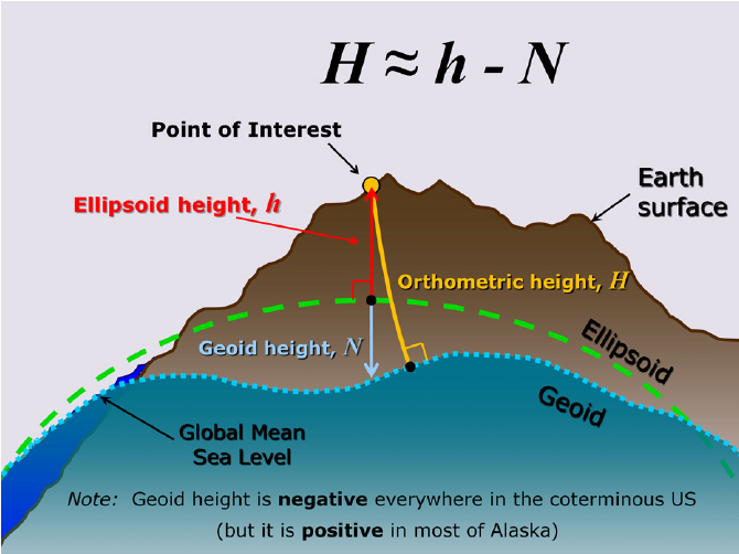
Seems to me WGS84 Ellipsoid would be the best since the origin is based from the center of the earth and is stationary? The mother of all monuments or benchmarks? Maybe this is why Google (and Emlid uses it for Reachview?) uses it? So reference is ellipsoid HEIGHT to point of interest or point measured.
The geoid and the Global Mean Sea Level obviously even though average, is still dynamic or LIVE. So reference is Orthometric HEIGHT to point of interest.
But ultimately I guess you still need to localize.
I would hope that with the introduction of L5 and dual-frequency capabilities for our personal devices that all of this will start to go away as Google Earth gets more accurate. I still don’t understand why GE still uses egm96 instead of egm2008 and I sure hope that they move to egm2020 when it is available… Here’s a cool tool for GE.
While Google is constantly improving their own terrain datasets resolution through technological advances (LiDAR, photogrametry, satellite), much of the original terrain data was derived from USGS SRTM data which was vertically referenced to EGM96.
I need some education here but a euclidean measurement would not account for the curvature of the earth, right? Euclidean geometry assumes a flat grid. In construction how are long distances accounted for between two points to account for curve of earth? Say I am constructing a very long pipeline from point A to point B. I could take a Euclidean measurement between two points and get a distance and I could also take a spherical (projected) distance and the values would vary substantially. However, when the pipeline is actually constructed on the ground would it not follow the general curvature of the earth rather than a straight line and its actual length be closer to the 1250 miles? If it was a straight line from a set angle it wouldn’t “make” it to Point B on the earths surface.
I guess I am asking why a Eucledian measurement is inherently more accurate, I can see this true for smaller, local sites but it must propagate error over large distances especially when talking true ground terrain. Not questioning, just here to learn.
For such LONG distances (versus a smaller LOCAL construction site based on a coordinate system), yes, you would have to account for the curvature for the earth obviously, or the incorrect amount of piping wouldn’t be ordered.
I leave this setting off in my use in FieldGenius, but not sure this feature accounts for that or not? Again, I don’t use it, so do not know. I assume other 3rd Party Survey software has this also.
When selected, the correction is applied to the computation of drawing coordinates only. Raw data will not be altered in any way. When available from your instrument, we recommend the use of that option and leave this setting toggled OFF in FieldGenius. Note: Be careful to not have this setting toggled ON in both your instrument AND FieldGenius.
Surely just some over exaggerated hypothetical musings for long distance perfectly spherical shaped earth pipeline construction :. For short distances on local sites how much departure does one expect from eucledian measurement to a curvature based one?
I wonder what the computation algorithm is based off, a projection of some sort I assume.


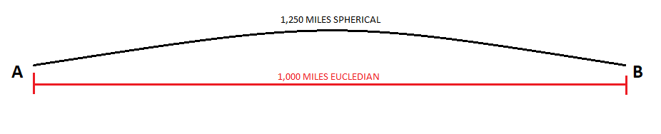
 :. For short distances on local sites how much departure does one expect from eucledian measurement to a curvature based one?